When Hard Bottom Isn;t Enough
Capt. Russ Walker
October 29, 2019
Cape Coral - Saltwater Fishing Report

"From My Tackle Box" by Captain Russ Walker
When Hard Bottom Just Isn't Enough.
Quick, load the boat. Get the rods, tackle, bait and let's be on our way. But Where do we Go Today?
Before we run off and get lost in a tizzy, let's take a look at our options. Fish tend to gather where food and protection meet up together. So, close into the shoreline we encounter many docks, wrecks, rip rap, pilings or even man-made, artificial reefs. All great for a fun day on the water. However, with the increased fishing pressure of today, many times these close in areas become overfished and tend to remain virtually non-productive for long periods of time.
Where you find it, an alternative can be a large expanse of rock or vugular spaced, rocky bottom. "Hard Bottom" as they say. It's great for fishing and can be highly productive. Spear Gun toting divers like it too.
Other options can include natural structural positions formed by tectonic plate movement or even volcanic deposition. Though the Gulf of Mexico provides many great opportunities for fish to gather, much of it is almost desert like as it relates to concentrations of fishable populations. As always, Structure is the name of the game.
Shipwrecks are great habitat throughout the area in varying depths of water too which produce great fishing opportunities. What better way to lure in a big AJ or Goliath Grouper, than the invitation of giant skeleton of an old shipwreck.
It's good to have an understanding of additional, natural, geological opportunities that await us offshore in the Gulf too.
The Gulf of Mexico covers an immense area and finds its depth mostly in an area known as the Desoto Canyon. A series of "down the coast" tectonic slip faults parallel to shoreline perimeters off the North American plate cause the waters to deepen the canyon walls within. One part of Desoto Canyon is known as "The Nipple" which remains uncommonly deep as it extends itself northeastward towards Destin, Florida. Many believe that the deep waters of the Nipple, so close to Destin, is the reason for so many shark attacks in that area as the waters remain deep so close to the shoreline.
Looking more in the area of the West and South West Coast of Florida we find a number of natural formations which support really great fishing. Let's explore the reasons why and where to find them.
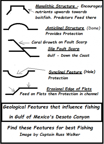
Note the Schematic to find a series of natural geological formations which occur regularly in the Gulf of Mexico.
Starting with the "Monolith" or Monolithic structure. Here we find a singular or even series of pinnacle type natural features which encourage current directed nutrients to flow from the depths towards the surface. This in turn invites bait fish to congregate and feed. It's an excellent place for predator fish the seek them out as a food source. A good example of this is the Middle Grounds, which is found 100 miles NNW of Tampa, Fl in the Gulf waters. There, a series of structural both natural and metamorphic marine growth, non-conforming advantage points combined with ridges and reef formations make for incredible fishing supporting many different species of fish.
Secondarily, yet similar to the Monolith is the "Anticline" or dome feature usually which always holds fish providing there is enough character in the localized rock. The "Hump" off Islamorada in the keys is a good example of this feature. Tuna love these structures and hunt them frequently. There are many in the waters offshore Lee County, Florida too. When viewing your GPS monitor, an Anticlinal feature will be shown on your contour map merely as a circle or as an elongated circle. The circle indicates there is closure or a completed mound on the floor at that position. Relief or heights in footage can be found in the contour denotations It's always good to hit a waypoint when you see one as a mark to return too. Faults often offset them.
Next: The "Slip Fault" is one of the most common, yet most prolific, natural, geologic structural fishing advantages of the group. Down the coast faulting provides a "scarp face" which allows soft and hard bodied corals to grow. It also presents itself as shelter and protection for the fish. Once a fault line is established, the fish find sanctuary and their numbers multiply greatly. This is a favorite spot of the Grouper species.
One thing to note is when you encounter a Slip Fault, your bottom depth contours will usually stack, due to extreme differences in the depths at that point. An example would be contours shown on your depth sounder will show a fairly flat bottom with plenty of spacing between each contour say from 75' to 80' to 85' then bam; the contours literally stack one over the top of the others as it falls from 85' to 95' indicating a 10' Fault Scarp
This is called a Ledge by many fishermen when in fact it is a "Down the Coast Fault."
This fault may run for miles on strike from your current position and can be identified as great return spots for fishing. When encountered, these areas should always be Way Point marked. Drift fish them on strike or criss- cross them. Mark each fish caught with a waypoint for what is usually excellent return fishing. Most times one crank off bottom is where the big Groupers will hit your bait. Squid or better yet, 5" Pinfish usually scores big. Faults or Ledges as we call them are some of my favorite places to explore for big fish.
Next up we have a "Syncline" or hole. Hey, there's no telling what has taken up residence inside a nice, deep syncline offshore, but I'll bet ya they won't be easy to get to the surface. A syncline will be marked with a circle too, with the exception of a V' pointing inward within the circle. When you see this, it's indicating a syncline or a ( hole ).
One thing that is for sure. No matter when you catch a fish offshore you should always hit the waypoint button. Here's why.
Let's say you've found a ledge and each time you make a drift across it you catch a nice grouper or Mutton Snapper. Hit the Way Point Button. You will never be able to make each drift identical to the previous one so before too long, you'll have a complete log of where you caught each fish on that trip. It is not important to take the time to name each waypoint. All marks on that trip will be in the same area and it will give you much needed information when you return next time for fishing that same area. Let's see here
looks like every time we crossed that ledge; we caught a fish. Dude, hit the Way Point Button.
After fishing an area, a number of times, it will begin to look like a road map of where to concentrate your efforts in your new fishing grounds and only you have the numbers 😊
Finally, in this article let's go back inshore inside the inter-coastal to a structural feature known as an "Erosional" or "Flats Edge". Other than docks and bridges, the most prolific inshore fishing areas are usually from 3' to 5' of water where the erosional edges of the grass flats are found. Near 5'/6' depth of water seems to be where the grasses tend to quit growing. The natural thing for tidal currents at that point is erosion. Grass Flatts, up on top hold the shrimp and bait fish. Predators swim up and down the erosional edges of these structures. They cruise up on the flat to strike at food, then dive back to the safety of the deeper channel waters when need be. The "Channel Break", as we call it is highly productive for many different gamefish and fighting species alike.
Natural Geologic features will always provide a structural advantage when looking for great places to find fish. I hope this information helps you to identify and utilize your sounder &maps better to determine the best possible fishing spots when you are way out in the Gulf.
Remember, when you clear your trails, I hope you didn't forget to mark the Way Points. You can erase the trails, but the waypoints will be live on and be your guide forever.
I don't really feel like fishing today. said No Fisherman Ever.
Have Fun.
Captain Russ Walker
Tide Walker Charters
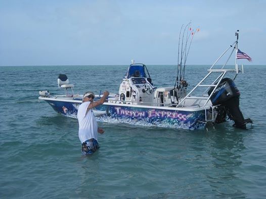
30" Red Grouper on the Ledge 40 miles out
Target Species:

AJ's, Gray Trigger, Bolt head Porgy, Red Grouper.
More Fishing Reports: